Key Information
| Title | Nature-Based Flood and Wildfire Risk Reduction in the Lelantine Plain (NATALIE Project) |
| Hazard | Multi-hazard: flooding and wildfire |
| Region and Country | Central Greece, Greece |
| Action Type | Pilot project |
| Further Categorisation | Nature-based flood retention; erosion control; wildfire fuel management |
| Maturity | Pilot under implementation |
| Key links | NATALIE Project — Central Greece case study NATALIE Project overview |
Context
The Lelantine Plain, located on the island of Evia in the Region of Central Greece, is exposed to recurrent flooding and wildfires. These hazards can interact and amplify their impacts: wildfires remove vegetation, reduce the soil's capacity to retain water and increase surface runoff and erosion during subsequent rainfall events. At the same time, modifications to the river system, land-use pressures and the expansion of settlements have increased the area's vulnerability to flooding. These interconnected risks affect agricultural land and production, rural and urban communities, local livelihoods and ecosystems. The Region of Central Greece and its partners are therefore implementing an integrated nature-based approach to reduce flood and wildfire risks and strengthen the long-term resilience of the Lelantine Plain.
Action Description
The NATALIE pilot combines practical nature-based interventions, wildfire-prevention planning and stakeholder co-design to reduce flood and wildfire risks in the Lelantine Plain. The action includes:
- The planned construction of 50 to 70 small traditional check dams in the Gerakari ephemeral stream, within the Lilas River catchment. The intervention aims to slow surface runoff, reduce soil erosion, support groundwater recharge and enhance local biodiversity.
- The implementation of prescribed burning as a forest-fuel management and wildfire-prevention measure. Owing to weather conditions, three pilot applications were carried out across the selected areas: two at Pournos and one at Angelaki, covering a total area of 27 stremmas (2.7 hectares), following cooperation with the relevant forestry authorities and local stakeholders.
- The development and official adoption of a comprehensive Fire Risk Management Plan by the Municipality of Chalkis. The Plan identifies wildfire vulnerabilities and prevention priorities and supports evidence-based planning and access to funding.
- Participatory workshops and co-design activities intended to build institutional and community capacity and prepare the ground for the wider implementation of nature-based solutions across the Lelantine Plain and other suitable areas of Central Greece.
The longer-term measures being explored include river and wetland restoration, the creation of riparian forests and the reconnection of rivers with their floodplains.
Nature-Based Flooding Solutions
Traditional small check dams have been used across the Mediterranean for centuries, initially to retain water for irrigation and other local uses. Under the NATALIE pilot, this traditional approach is being adapted and tested as a nature-based measure for reducing flood risk, controlling erosion and restoring natural water-retention functions.
The pilot plans to construct 50 to 70 small check dams, including log and stone structures, along the Gerakari ephemeral stream within the Lilas River catchment. By slowing surface runoff and retaining sediment, the structures are expected to reduce erosion and downstream flood risk, increase water infiltration and support groundwater recharge. The temporary retention of water may also create small habitats that benefit local biodiversity during dry Mediterranean periods.
The intervention area was selected following field inspections of 11 stream locations and consultation with the relevant forestry authorities. The broader site-selection methodology considers geological, hydrological, anthropogenic and topographic data at catchment level. It is designed not only to support the pilot intervention but also to identify other tributaries where similar measures could be implemented in the future. This methodology may therefore support the replication and scaling-up of nature-based flood-management measures within the Lilas River basin and in other suitable regions.
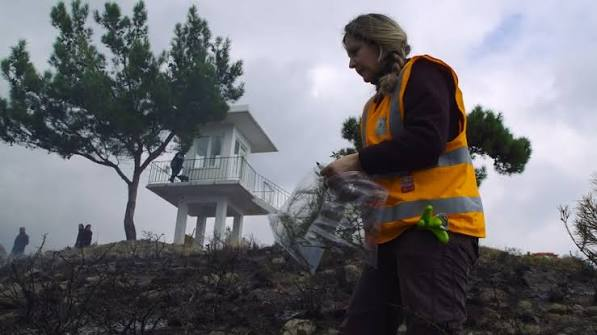
Field mapping and site assessment along the Gerakari ephemeral stream for the planned installation of small stone check dams as a nature-based flood-risk reduction measure. The photographs show post-wildfire conditions and candidate intervention locations; construction is not depicted.
Photographs supplied by the Region of Central Greece.
Nature-Based Wildfire Solutions
The wildfire-risk component of the pilot combines forest-fuel management, municipal prevention planning, technical training and community engagement.
Prescribed burning is being tested as a forest-fuel management technique. It involves the planned and controlled use of fire by appropriately trained teams, under defined weather, safety and operational conditions. Its purpose is to reduce the amount and continuity of combustible vegetation, helping to limit the intensity and spread of future wildfires and making fire-suppression operations safer and more effective.
The selection of the pilot areas was undertaken in cooperation with the Evia Forest Directorate, the Chalkis Forestry Department, local authorities and other relevant stakeholders. Awareness activities were organised for the local communities, together with technical training for public authorities and volunteers involved in the pilot.
Owing to weather conditions, three prescribed-burning applications were carried out across the selected areas: two at Pournos and one at Angelaki. Together, the treated locations cover a total area of 27 stremmas (2.7 hectares).
In parallel, WWF Greece and the Agricultural University of Athens developed a comprehensive Fire Risk Management Plan for the Municipality of Chalkis. A draft was presented for public consultation in April 2025, and the final Plan was presented in June 2025 following the incorporation of stakeholder feedback. The Plan was subsequently officially adopted by the Municipality of Chalkis.
The Plan documents wildfire risks and vulnerabilities, identifies and prioritises prevention needs, supports evidence-based municipal planning and facilitates access to national and European funding. Together, the Plan and the prescribed-burning pilot strengthen local capacity for proactive and long-term wildfire prevention.
Building Institutional Capacity on Nature-Based Solutions
The pilot is designed not only to implement individual nature-based measures but also to strengthen the institutional capacity required for their wider and more systematic use in Greece. Nature-based solutions have so far been applied on a relatively limited and small-scale basis, and their integration into established planning, regulatory and investment processes remains at an early stage.
The Region of Central Greece plays a coordinating and convening role, bringing together municipalities, forestry and civil-protection authorities, universities, environmental organisations, technical partners, local communities and volunteer groups. Participatory workshops and technical meetings are used to share evidence, identify implementation barriers, incorporate local knowledge and co-design adaptation and risk-reduction measures.
The pilot is also developing transferable methods for site selection, monitoring, stakeholder participation and municipal wildfire-prevention planning. The evidence generated on technical performance, cost, environmental benefits and community acceptance is intended to support future decision-making and investment in nature-based solutions.
Lessons from the Lelantine Plain will inform the potential expansion of these measures across the wider Lilas River catchment and their replication in other river basins and fire-prone areas of Central Greece. In this way, the pilot aims to connect small-scale demonstration activities with longer-term regional climate-resilience planning.
Timeline & Evolution
The Lelantine Plain pilot is being implemented as part of the EU-funded NATALIE project, which runs from 1 September 2023 to 31 August 2028.
- September 2023: Start of the NATALIE project.
- April 2025: Public consultation on the draft Fire Risk Management Plan for the Municipality of Chalkis.
- June 2025: Presentation of the final Fire Risk Management Plan following stakeholder consultation.
- 2025: Official adoption of the Fire Risk Management Plan by the Municipality of Chalkis and completion of three pilot prescribed-burning applications: two at Pournos and one at Angelaki, covering 27 stremmas (2.7 hectares) in total.
- October 2025: Second participatory workshop in Chalkida, focusing on the co-design of flood-risk and climate-adaptation measures.
- October 2026: Planned commencement of the construction of small check dams in the Gerakari stream; implementation status should be verified immediately before submission.
- August 2028: Completion of the NATALIE project and consolidation of monitoring, evaluation and replication activities.
Cost & Resourcing
The NATALIE project has a total budget of €16.44 million, including an EU contribution of approximately €15.03 million under Horizon Europe.
The combined net EU contribution allocated to the five funded Greek beneficiaries participating in the Lelantine Plain case study is approximately €2 million (€1,999,062.50). This amount supports their participation throughout the project's 60-month duration, including staff time, research and modelling, stakeholder engagement, planning, monitoring, coordination and project-management activities.
The Region of Central Greece has a net EU contribution of €121,875 for its participation in the project. This allocation supports the Region's coordination, stakeholder-engagement, reporting and implementation responsibilities.
The portion of the case-study budget specifically allocated to the physical implementation of the check dams and prescribed-burning measures has not been separately identified in the publicly available financial information.
Staff time: The Region of Central Greece's project allocation includes up to 23 person-months across the project implementation team, including external expertise and participating permanent staff. The precise distribution of staff time is determined according to project needs and validated through the project's reporting procedures.
Actors & Governance
The World Wide Fund for Nature, Greece (WWF): the lead partner for the Lelantine Plain demonstration site. WWF Greece coordinates the Greek case-study partnership and leads key wildfire-prevention activities, including the prescribed-burning pilot and the development of the Fire Risk Management Plan for the Municipality of Chalkis.
The Region of Central Greece: the regional public-sector partner responsible for coordinating its participation in the project, convening regional and local stakeholders, supporting participatory and co-design activities, and connecting the pilot with wider regional climate-resilience planning. The Region also supports the potential replication and scaling-up of nature-based solutions in other suitable areas of Central Greece.
Regional coordination team: Thomas Kapsalis, External Expert and Scientific Lead for the Region's participation in NATALIE; Roula Kechri, Advisor to the Regional Governor for European Programmes and International Relations, supporting institutional coordination and European-programme engagement; and Konstantinos Meletis, Director of the Directorate of Environment and Spatial Planning, supporting technical and administrative coordination.
The Municipality of Chalkis: local-government partner with responsibilities relating to civil protection, wildfire prevention and local implementation. The Municipality participated in the development and consultation of the Fire Risk Management Plan and formally adopted the completed Plan.
The University of Thessaly: academic partner supporting stakeholder engagement, co-creation processes and the methodological development of the project's Transformation Labs. The University also contributes scientific and technical knowledge to the Greek case study.
The National Technical University of Athens: research and technical partner contributing to climate-hazard modelling, the assessment of nature-based solutions, the development of performance indicators and the NATALIE knowledge and Digital Twin tools.
Global Infrastructure Basel Foundation: international partner supporting the consideration of investment, financing and scalability aspects for nature-based solutions.
Other stakeholders: forestry and firefighting authorities, civil-protection services, local communities, volunteer groups, land managers and other public and private stakeholders contribute local knowledge, technical input and operational support.
Best Practice Principles
Address interconnected climate risks rather than individual hazards in isolationWildfires and floods can interact and amplify their impacts. The loss of vegetation following a wildfire can increase runoff, erosion and downstream flood risk. Adaptation planning should therefore assess compound and cascading risks and identify measures that can provide benefits across more than one hazard.
Combine physical interventions with institutional planningSmall-scale nature-based measures are more effective when supported by appropriate governance, prevention plans, technical capacity and long-term investment. In the Lelantine Plain, check dams and prescribed burning are combined with municipal wildfire planning, stakeholder engagement and regional coordination.
Engage local authorities, technical services and communities from the outsetForestry authorities, civil-protection services, municipalities, researchers, local communities and volunteer groups hold different forms of knowledge that are necessary for effective implementation. Early and continuous participation helps improve site selection, operational planning, public acceptance and the long-term maintenance of interventions.
Design pilots for monitoring, replication and scaling-upPilot measures should generate evidence that can inform future investment and implementation. Site-selection methods, performance indicators, monitoring results, cost information and lessons on community acceptance should be documented in a transferable form. This allows successful measures to be expanded across the wider catchment and adapted for use in other regions.
Next Steps
The Lelantine Plain pilot will continue until the completion of the NATALIE project in August 2028. The principal next steps are:
- Complete the technical preparation and construction of 50 to 70 small check dams in the Gerakari stream.
- Continue or complete the planned prescribed-burning programme, subject to the applicable authorisations, weather conditions, safety requirements and operational assessments.
- Monitor the performance of the implemented nature-based measures, including their effects on surface runoff, erosion, groundwater recharge, biodiversity and wildfire risk.
- Assess implementation costs, operational requirements, environmental and social benefits, and stakeholder acceptance.
- Support the Municipality of Chalkis in using the adopted Fire Risk Management Plan to prioritise prevention measures and identify appropriate sources of funding.
- Continue participatory workshops, technical cooperation and knowledge exchange with public authorities, scientific institutions, local communities and volunteer groups.
- Refine the methodology for identifying other suitable tributaries and locations where similar nature-based measures could be implemented.
- Explore financing and investment mechanisms for expanding nature-based solutions beyond the initial pilot sites.
Following the completion of the pilot, the evidence and implementation experience generated in the Lelantine Plain will be used to assess the feasibility of scaling the measures across the wider Lilas River catchment. Successful approaches may subsequently be incorporated into broader regional climate-adaptation and disaster-risk-reduction planning and replicated in other flood- and wildfire-prone areas of Central Greece.